
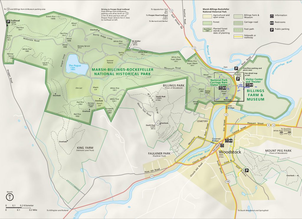
This is a description of walking the Marsh-Billings-Rockefeller National Historical Park and adjacent properties. The primary route circumnavigates clockwise the entire area without ever walking on an auto road. Diversions from the circumnavigating route are included for those ambitious to reach every overlook, peak, and the Pogue. Many places to enter or exit for a proper road are given. The official National Park Trail Map is only partly helpful as it is mostly restricted to the Park. Thus, “Park” here means the entire area bounded by proper roads.
For persons new to the Park, the guide may help them explore different parts of the Park, feature by feature. For experienced Park walkers, this is an efficient way say “I can’t believe I did the whole thing.” Approximately 25 (depending on how one counts) trails are used for Having an official map in hand in not assumed. The primary route takes non-stop about 3 ½ hours, without the optional features which are in parentheses
Key sections:
From Billings entrance to Town overlook: 45 minutes
From Town overlook to King Farm: one and ¾ hours
From King Farm to Prosper Rd. parking lot: 50 minutes
From Prosper Rd. parking lot to Billings entrance: one hour
Starting at the Billings entrance
At the Billings entrance to the park at the crosswalk, head up on the main road past the mansion until you come to walking paths going right and left (about 10 minutes). Take the left with a sign for Cemetery Rd. Proceed along past an iron gate across the path. Immediately to your right is a narrow rocky path, Lower Link Trail. Follow that trail, pass by the right turn to Upper Link Trail. The path gets steep for a moment. Turn left at a trail intersection. You will soon come upon another path. Go right and uphill. Shortly a sign says you are on the Faulkner Trail. Stay on it as it goes upwards through several switchbacks. The switchbacks come more quickly, the path is steeper, and you come up to a flat open area with benches. Keep moving upwards, holding onto wire cables, until you reach the top and a bench. The town is below to the southeast. From when you enter the Faulkner Trail and reach the top is about 25 minutes, and the time from the entrance into the Park about 45 minutes.
From this overlook, walk down the road, the Mt. Tom Road. You will see Mt. Killington far to the west. In about 10 minutes, take a left onto the Larch trail. Winding through white pines planted in 1911, it issues back onto the Mt Tom Road.
(Optional visit to North Peak: on the Mt. Tom Road, watch for a path to the right and up, with a sign for the Billings Trail. Take it, rising, and shortly you will see a left turn for the Billings Trail, but keep straight and you will reach a large flat summit, the views south and west blocked in the summer by trees. Time to the top is five minutes.)
Picking up at the return to the Mt. Tom Road from the Larch Trail, you can terminate the walk at this point in two ways. One is by way of a path to the left, just next to the Larch Trail entrance. This path descends in the woods and ends on Frenchs Rd. You then walk down the road for a half mile. At Rose Hill Rd, take a left to go back into town. It is another 1 ½ miles to the Billings parking lot. The other way to end the walk is to continue on the Mt. Tom Road, which runs into a larger carriage road, the Mountain Road, at a horse watering stand. To the left, you come to the Pogue pond immediately. To the right, the Billings entrance is in about 30 minutes away.
(That exit down Frenchs Rd. allows you to visit a Roman god. As you walk down the road, you come to handsome estate-like gate on the left. The estate has been cleared of any habitation. Enter and walk down the driveway, but then at a clearing cut to the right and place yourself in the middle of a clearing. Look south into an attractive stand of tall trees. There may be some fallen trees in the woods. Walk south over or around the trees. In the center of a restful place in the woods is a statue with the head of Jupiter. Observe other strange Roman and Eastern objects left in the estate.)
To continue on the circumnavigation at the intersection of the Larch Trail and the Mt. Tom Road, head left on the road. Pass an open field with a good view looking south. Very soon you see a path skirting off to the left. Take that and you come to the edge of a large field, the Elm Lot. Continue straight along the edge of the field, and very soon there is an entrance on the left into the woods, with trail signs to go left or right on the Red Pine Loop. Take the left (“lookout”), passing some Norway spruce on your left (planted 1887) and very soon you will come upon an overlook facing south, with Mt. Ascutney in the distance. Follow the trail as it leaves the overlook, passing through a woods of red pine, until you come on a large path with signage and other paths across from you.
Take the immediate left. Note a blue cross-country sign on a tree about the Red Pine Loop. Very shortly there a Y for the King Farm Loop. Take either, but the left way is prettier. They both bring you to a southern facing overlook, the King Farm overlook (the farm is below, behind trees). Facing south at the bench, look left and see an opening in the woods (you would have come this way had you taken the left for the King Farm Loop). Go onto the path heading downhill, with some turns, until you come to an intersection with trail signs. Cut left and head downhill in a field, bearing right around a large stand of trees obscuring a small pond. Continue until you reach King Farm.
The elapsed time from Billings entrance to the first overlook over the town is 45 minutes, from there to the second overlook about 30 minutes, from there to the King Farm overlook, about 15 minutes, from that overlook to King Farm, 15 minutes, for a total of 1 ¾ hours.
At King Farm if you wish to walk back to town from here, walk down the King Farm driveway, turn left on Rose Hill Rd, and you will get into town in less than two miles. Or, you can turn right on Rose Hill Rd. and descend to the Farmer’s Market.
Facing the front of the King Farmhouse, with the barns to the right, find the good path that runs to the left of the house. It is in effect an extension of the driveway up from Rose Hill Rd. Walk along this path. Take the path parting off to the right and uphill. (If you keep on straight you reach Prosper Rd. and the sculpture park on the Davenport estate.) The path can get very muddy in the Spring, in which case find a quick turn uphill to a parallel path, called the Poet’s Trail. The two merge in a few minutes. Keep heading upwards for 15 minutes, as it bends further uphill and right, and at an intersection take the hairpin turn left onto Acer Loop. In about ten minutes you come to signs designating Ashes Ashes Trail straight ahead and Acer Loop to the right. Go straight onto Asher Ashes. Soon you will see a stone wall as the trail bend right. Step through an unmarked opening in the wall.
You are now on a narrow and unmarked path, almost a deer path, so let’s call it the Deer Path. Keep heading slightly up, staying right and through a shallow saddle, until you enter onto a bend in a proper trail. This is the Maple Trail. Go left. At an intersection with White Pine Trail, keep left. In a few minutes you will walk into the National Park’s nursery. This milestone is roughly 45 minutes from King Farm. There is a picnic table. Continue on, through Norway pine, and you reach McKenzie Rd. which heads to the right heads towards the Pogue. Make a sharp left, very shortly then a path to the right, and through a stand of Scotch pine you arrive at the Prosper Rd. parking lot. The total time from King Farm to the parking lot is 50 minutes.
(Optional loop to the Maple Trail overlook. This overlook is deep within the entire park area. Instead of going left after leaving the Deer Path, go right, up the Maple Trail. In about fifteen minutes you will reach a clearing, with a bench and a view south to Mt. Ascutney. If you continue along this trail, descending, you will soon approach a corner of the large Elm Lot field adjacent to the Pogue.)
At the nursery you can elect to depart from the park, going onto Prosper Rd, and turning left walk back towards King Farm. In 15 minutes you will see on your right the sculpture park on the Davenport estate. Just after the estate, leave Prosper Rd for a path on the left. That returns you to King Farm.
(Optional loop to the over the Pogue overlook. While on the Maple Trail, when you reach the White Pine trail to the right, take it. From here on it is largely uphill. Take the right turn onto “overlook” and proceed for another fifteen minutes until you reach the top. The overlook’s view of the Pogue to the east is blocked when the leaves are on the deciduous trees. Returning, you can take a right at the end of the “overlook” path and onto the West Ridge Trail. In less than ten minutes you come to an intersection with the Maple Trail, go right, and you reach the nursery. The entire loop will take up to 40 minutes.)
From the parking lot get on the Prosper Trail with a small bridge just below the entrance, and walk uphill for about ten minutes where there is an intersection with the North Slope Trail. Go left on the North Slope Trail. Soon, passing through a stand of Scotch pine from the 1930s, you will come to a clearing, which looks like an abandoned site for a house. Looking straight out from this open area, you will see to the northeast Gilbert’s Hill, the site of the first ski lift. This location is not on any map; I call it the Gilbert’s Hill overlook.
(Optional loop to the Pogue: Continue on the Prosper Trail from the parking lot until it ends at McKenzie Rd. Take a left then an immediate right at the intersection of McKenzie Rd and the North Ridge Loop. The Pogue soon becomes visible on the right. Time from the parking lot to the Pogue: 20 minutes.)
(Optional loop to the overlook on North Ridge Loop. At the McKenzie Rd.- North Ridge Loop intersection, turn left from McKenzie onto the North Ridge Loop. In 15 minutes you will see a bench on the left. The view is northwest, overlooking the old Mt Tom ski hill and further away Gilbert’s Hill.)
Leave the Gilbert’s Hill overlook to the right, along a path that descends gradually through the woods for 15 minutes. This path, not on any map, I call the Bassett Trail, for the farm at the base at the Rte 12 – Pomfret Rd intersection. You come to an opening which is a former ski trail for the old Mt. Tom ski area. A path may be hard to find, but keep heading west without losing altitude, and you will pass through several rows of trees and other ski trails. In a few minutes you come to a large woods in front of you and a trail into the woods, while below are more ski trails and trees. (The trail into the woods is the Ravine Trail. Keep turning left and you get to the Mountain Road.) Work your way downwards on a ski trail around a line of trees. Soon a white house, the childcare center, will appear below. Keep heading down until you reach the house. On the right, there is a path with a sign, “Stewardship Trail to National Park.” Take that. Shortly there is a fork. The right takes you to a carriage road, the left to a path that runs along Rte 12. By either way, you will reach the Billings entrance in a few minutes. The time from the Prosper parking lot to the Billings entrance by this route takes an hour.